




Creotech Instruments, Poland’s largest space mission integrator, has presented the first Earth observation images captured by the Mikroglob-1 satellite, operating as part of the Mikroglob Satellite Earth Observation System (SSOZ), developed under a contract with the Armament Agency. The released materials include, among others, images of Los Angeles International Airport, the Los Angeles metropolitan area, New Orleans Airport, and the city of Dalian in China. The data were acquired in visible light and near-infrared (NIR), demonstrating the capabilities of technologies being developed by the company as part of a strategic project for Poland’s security and defence sector.
"The first images represent an important milestone for us, as this is the first time we can publicly present data acquired by a satellite that forms part of the Earth Observation System we are building. The system enables both detailed observation of individual objects and the acquisition of data covering much larger areas. Another important functionality is the ability to capture imagery in different spectral ranges, including near-infrared, which makes it possible to obtain additional information about the characteristics of the observed terrain. This is an important stage confirming the capabilities of the technology we are developing, as well as the competence of Polish industry in building advanced satellite systems. Mikroglob demonstrates that domestic solutions can combine high imaging detail, flexibility in the use of data, and the ability to carry out tasks that are important from a security and defence perspective. The next stages of the project will further increase these capabilities as the entire constellation is developed."

dr hab. Grzegorz Brona
President of the Management Board of Creotech Instruments S.A.
The presented images were captured as part of the satellite acceptance phase. Mikroglob-1 was launched into orbit on 7 July 2026. Before the target quality parameters can be achieved, it is necessary to move the satellite into its target orbit, complete the calibration of the imaging system, and complete the calibration of the system responsible for precise satellite pointing. This work is being carried out before the system is handed over to the Ministry of National Defence.
From an airport to entire sections of a metropolitan area
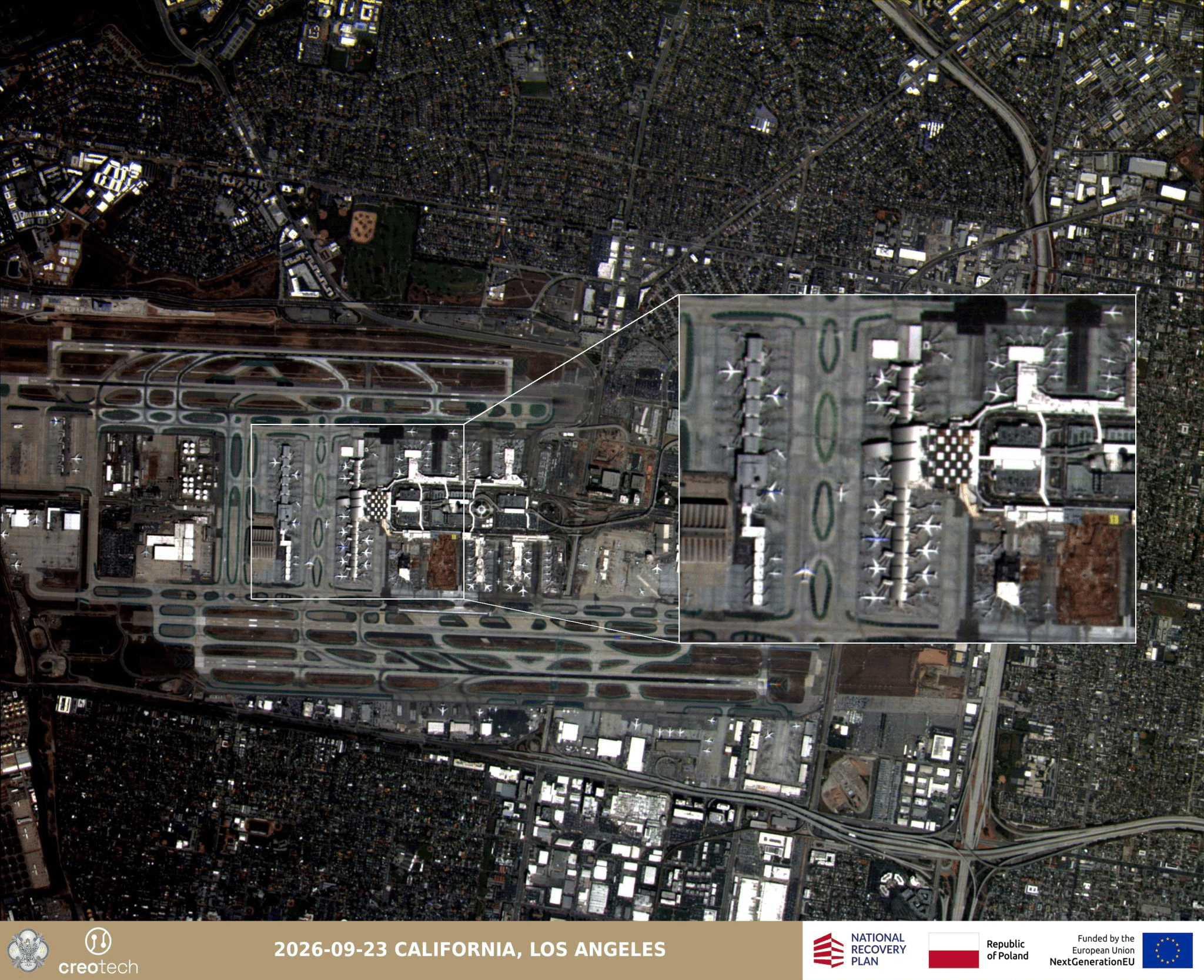
The first satellite image shows Los Angeles International Airport (LAX). The image, captured on 23 September 2026, covers an area measuring 5.5 × 7.1 km. The airport infrastructure and its immediate surroundings are visible in the image.
California, Los Angeles – download file

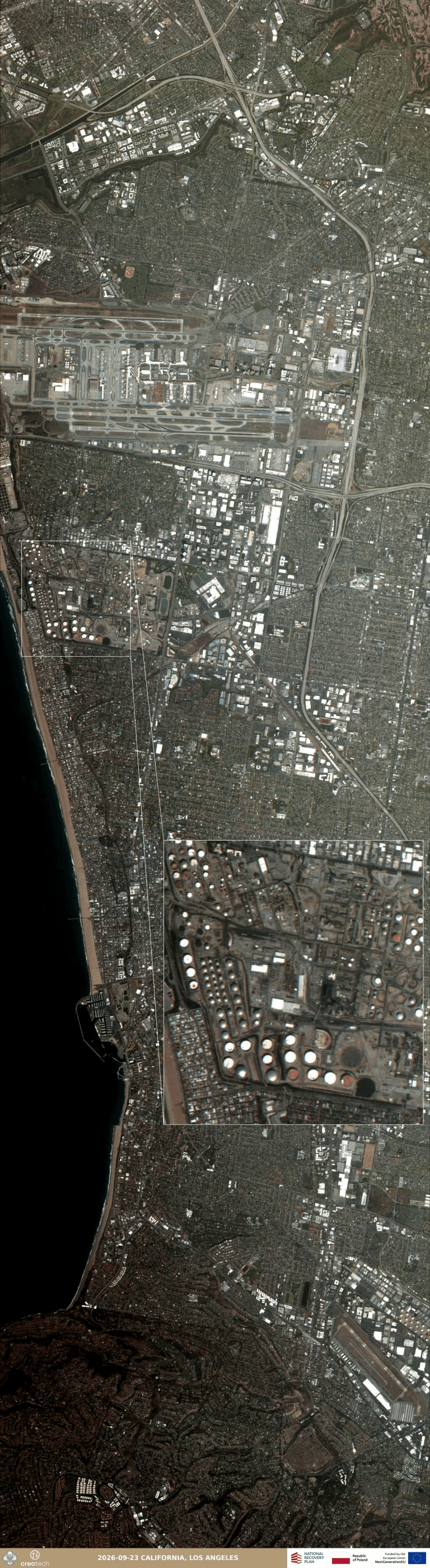
The second image shows a much larger section of the Los Angeles metropolitan area, extending from the vicinity of LAX Airport to Torrance. The area covered is approximately 24 km long and 7.1 km wide. The enlarged image shows, among other things, a refinery complex.
Both examples demonstrate two complementary applications of satellite data: detailed observation of a specific object and analysis of a large area within a single image.
California, Los Angeles – download file

Different wavelengths, more information about the observed terrain
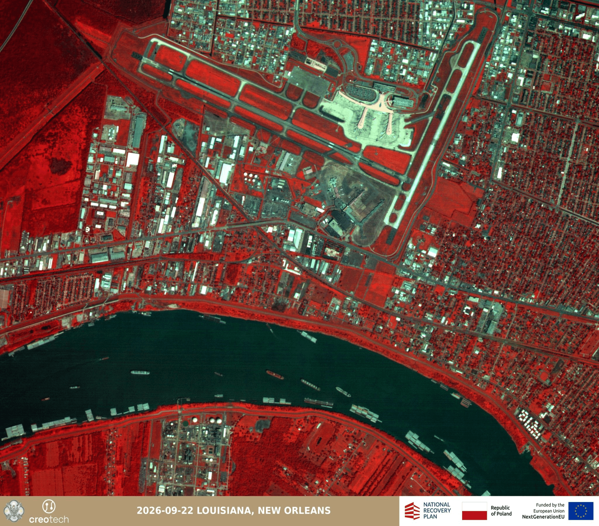
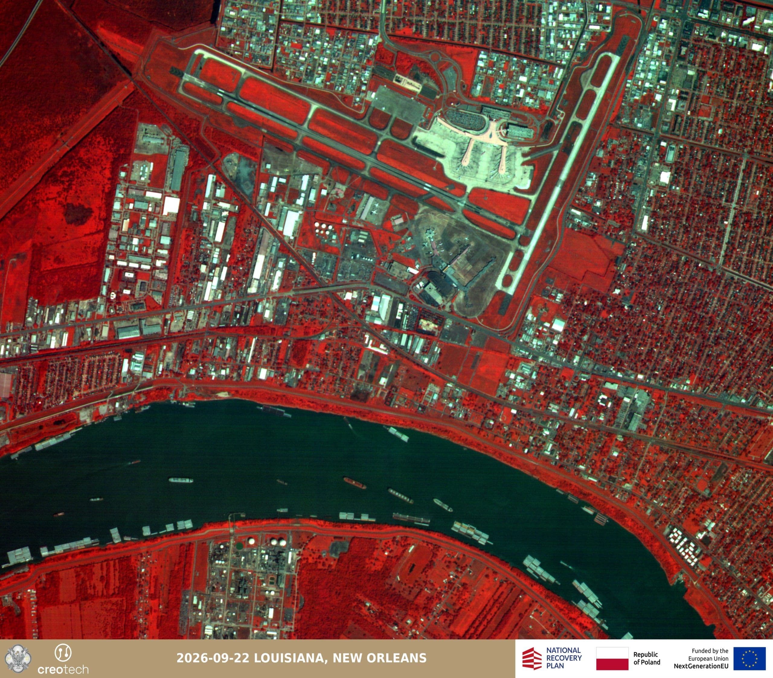
Mikroglob-1’s capabilities also include capturing images across a broad range of visible-light wavelengths and in the near-infrared range. One example is an image of Louis Armstrong New Orleans International Airport and a section of the Mississippi River, captured on 22 September 2026. It covers an area measuring 9.9 × 6.3 km.
The RGB image uses the three basic visible-light bands – red, green, and blue. This enables detailed observation of objects and infrastructure, as well as their surroundings.

Louisiana, New Orleans – download file

The same area was also imaged using the NIR, or near-infrared, channel. This is a range of light that is invisible to the human eye and can provide additional information about the characteristics of the observed terrain.
NIR data are used, among other applications, in vegetation and environmental analysis, as well as in assessing damage caused by natural disasters or military operations. In Earth observation systems, they can also provide an additional source of information used to monitor specific areas.
The NIR image of the same area in New Orleans measures 5.4 × 5.5 km.
Louisiana, New Orleans – download file

Details visible from orbit
Another example is an image of the port of Dalian in China. A particularly interesting object captured here by Mikroglob-1 is the area of the Dalian Shipping Heavy Industry Group Company Ltd. shipyard, where China’s fourth aircraft carrier, referred to by analysts as Type 004, is being built. It will most likely be equipped with two nuclear reactors, whose compartments, not yet covered by the deck, are clearly visible in the image. The image captured by the Polish satellite therefore demonstrates the practical potential of domestic technology for observing objects of strategic importance.
The material captured in the panchromatic band covers an area measuring 5.3 × 7.4 km.
The relatively high exposure of the detector in this mode makes it possible to obtain a detailed image of the observed area. The imagery can be used to analyse, among other things, buildings, roads, bridges, and port infrastructure.
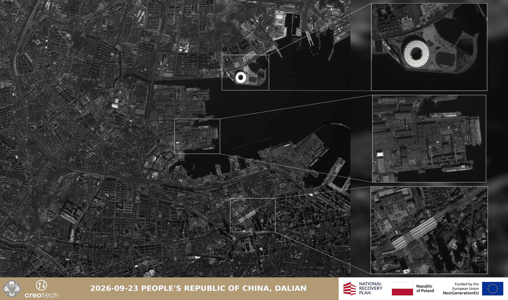
Dalian, People’s Republic of China – download file

The first images from the Mikroglob project demonstrate in practice how data acquired from orbit can combine detailed observation of individual objects with analysis of large areas. At the same time, they represent another stage in the development of a system intended to provide Poland with its own satellite Earth observation capabilities.
The First Element of the Mikroglob System
Mikroglob-1 is the first of four satellites in the SSOZ Mikroglob system, which Creotech Instruments is building on behalf of the Armament Agency. The system is based on the company’s proprietary HyperSat satellite platform, which provides the technological foundation developed by Creotech Instruments, Poland’s largest space-sector company. This solution was also used in the company’s previous projects, including the PIAST, which was a training mission. Experience gained through successive projects makes it possible to increase the maturity of Polish technology and further develop domestic capabilities in satellite design, integration, and operations.
Mikroglob in Poland’s National Satellite Observation System
The Mikroglob project forms part of the broader development of Poland’s satellite Earth observation capabilities, encompassing both very-high-resolution systems and solutions providing a larger number of satellites and more frequent access to imagery. According to publicly available information, in 2022 Poland signed an agreement with Airbus Defence and Space for the delivery of two very-high-resolution reconnaissance satellites, with a resolution of approximately 30 cm. Their launch into orbit is planned for 2027. The value of the programme was set at EUR 575 million net.
Mikroglob complements these capabilities. A value of the programmeis only PLN 453 million net (approx. EUR 105 million), while the larger number of satellites makes it possible to increase the frequency of observations of selected areas, whereas very-high-resolution solutions provide the ability to acquire detailed imagery of individual objects. The two types of capability can therefore perform complementary functions within a satellite reconnaissance system.
The project is co-financed under the National Recovery and Resilience Plan (KPO).
Related news
Full Constellation of Polish Mikroglob satellites placed in orbit
02/10/2026
Creotech Instruments will implement the Twardowski project for ESA, phase 0/A of the lunar resources mapping mission
23/07/2026
Earth through the eyes of PIAST. New images from the Polish satellite constellation
08/06/2026
Creotech Instruments to deliver a project strengthening the security of PNT systems
12/02/2026
Stay up to date with Creotech Instruments
Discover what we're working on, explore our latest projects, and find out what's new at Creotech Instruments.